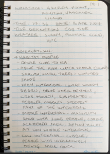
Location: Gartley Point, Royston, Vancouver Island.
Lat/long: 49383.65 N, 1245510.63 N
Date of visit: April 16, 2024
Time: 17:36
Tide description: ebbing
Weather: Sunny, minimal cloud, 16oC.
General description:
Gartley Point is a beach front located within the village of Royston, a coastal community which is situated to the south of the Courtenay on Vancouver Island. Gartley Point is located just south of the Trent River, overlooks Baynes Sound and includes grassy salt marsh. My area of interest is just south of the grassy salt marsh.
A number of houses are located above the high-water mark (HWM) at the top of a gentle slope. They are partially obscured by tall, evergreen trees. Waters adjacent to the beach are relatively calm as the beach itself is sheltered by the north-western spit of Denman Island approximately 3.4 km east of Gartley Point. The total area available for foot access will depend on the tides; when I visited low tide was at 18:30 so there was a lot of beach to cover. By my estimation, I was able to walk as far out as 250 metres north-east of the top of bank. The beach is open for public access and there were a few other dog walkers in the area at my time of visit (see Photos, Field Notes Page 1).
Topography and Substrates:
The beach profile was gently sloping from the high to middle intertidal (see page 2 of field notes for the beach profile). The middle intertidal area was predominantly flat and this continued into the low intertidal.
Substrates varied across the intertidal range; large woody debris and dense Pacific oyster (Crassostrea gigas) shell debris were dominant in the high intertidal accompanied by larger cobbles, pebbles and some gravels, in the middle intertidal sand was dominant and in the lower intertidal cobbles, pebbles and shell coverage was dominant.
Flora and fauna:
Flora – trees were present beyond the HWM and provided some limited shade which varied in angle during the time of my survey. I noted some herbaceous species, predominantly within the high intertidal zone but some within the middle intertidal e.g. pickleweed (Salicornia virginica). Red and green algae (kingdom Protista) were inconsistently found through parts of the middle intertidal zone, but generally in greater abundance in the low intertidal zone.
Fauna – I observed some bird presence whilst I was there, predominantly gulls and some other marine birds were visible at sea. Abundance and diversity of molluscs was high both in the high and low intertidal and less within the middle intertidal. There were so many Pacific oyster shells in the high and low intertidal that it was impossible to avoid foot contact. Pacific oyster shells in the high intertidal zone were notably bleached, unattached and deceased. Oyster shells in the high intertidal were bleached and seemingly carried up by the tide. Other molluscs included butter clam (Saxidomus gigantea), Japanese falso cerith (Batillaria attramentaria), and varnish clams (Nuttallia obscurata). Crustacean species observed included acorn barnacles (Balanomorpha) and dungeness crab (Metacarcinus magister) moults, the latter was mainly washed up in the high intertidal zone (see page 3 of field notes).
Three questions:
- There was a very high abundance of epifauna on the beach, particularly in the high and low intertidal. This environment is relatively untouched, could this be a reason why they are flourishing? How might this compare to other similar beach profiles?
- There are a number of different epifauna species present on this beach, does habitat competition play a part in their growth, abundance and diversity?
- How might the general setting of the beach i.e. sheltered and habitat profile, play a part in the species that are present and their abundance?
-
Field Notes, Page 1 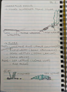
Field Notes, Page 2 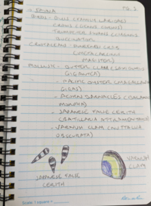
Field Notes, Page 3 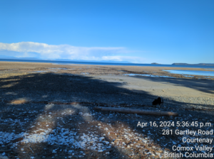
Looking east, Gartley Point -
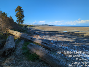
Looking north, Gartley Point. 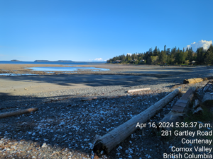
Looking south, Gartley Point 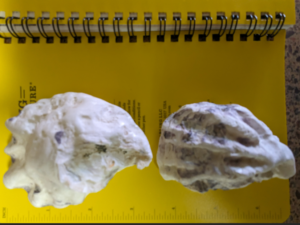
Pacific oysters (Crassostrea gigas)
Hi, a very cool study site and some good initial questions to continue to explore. I probably need to see blog 3 before seeing if I have any advice for your field data sheet.