Sandra Smith, Blog post 1.
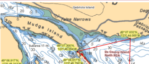
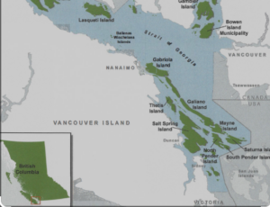
My study object’s location is the marine channel between Gabriola island and Mudge island in the southern Salish Sea that runs North-South between Vancouver island and the Sunshine Coast in British Columbia. The specific marine channel is known as the False Narrows and has the GPS coordinates 49.135° (latitude) and -123.78415°.
Between the northernmost and the southernmost tip on the Northshore of Mudge Island, the False Narrows are 2 km long and have a depth of about 3-9 meters. The narrows experience strong tides which create currents up to 4 knots several times daily, whereby summer tides are more extreme than winter tides. At the same time, the differential of high and low tides can exceed 4.5 meters, which means that not only are marine organisms in these narrows exposed to long times out of the water but also require strong anchorage in order to withstand the current.
With regards to my study, my interest is to examine some of the sessile life forms and their interactions on the reef that runs along the False Narrows. At low tide, it is possible to kayak up very close to the reef which is situated in the center of the channel and observe a large number of marine organisms such as sea cucumbers, anemones, bull kelp, sea stars, urchins, fish, eagles, herons, gulls and so on. Even though the organisms on the reef are subject to extreme conditions, the biodiversity and magnitude of life in that particular niche is exceptionally rich.
My particular interest within this setting is the abundance of bull kelp and other marine plants which form underwater forests that interact with other organisms as well as the survival strategies of sessile organisms on the reef. I will likely have to choose one of these interactions for my project as either one could inspire several studies.
Below is a map to locate my study area. The city of Nanaimo and Gabriola island itself are good departure points if one is not familiar with the location.
Both maps can be found on the Department of Fisheries and Oceans web site at https://www.pac.dfo-mpo.gc.ca/fm-gp/maps-cartes/areas-secteurs/index-eng.html#area-table